Colombian Authorities Release Preliminary Report on Cessna 402C HK2522 Crash in Urrao, Antioquia
Preliminary evidence suggests a Controlled Flight Into Terrain (CFIT) scenario, possibly influenced by weather conditions and loss of situational awareness.

Colombian aviation authorities have published the preliminary report on the Cessna 402C HK2522 accident that occurred on January 8, 2025, in Urrao, Antioquia. The report details the flight circumstances, crash site location, weather conditions, and initial investigation findings. Early data suggests that operational and meteorological factors may have contributed to the accident.
Flight Details and Last Recorded Data
On the day of the accident, a Cessna 402C, registered HK2522, was operating a non-scheduled passenger flight between Juradó (SKJU) and Medellín (SKMD), Colombia, when it collided with mountainous terrain in Urrao, Antioquia. The crash resulted in the death of all 10 occupants, including two crew members and eight passengers.
The aircraft was operating under Visual Flight Rules (VFR) and departed Juradó at 16:53 local time (21:53 UTC), with a planned cruising altitude of 11,500 feet. The last ADS-B record, captured at 17:32:50 HL (22:32:50 UTC), showed the aircraft descending to 10,675 feet at 176 knots, heading 097°, before disappearing from radar.
Crash Site Location and Wreckage Assessment
The aircraft was located on January 9 at 16:30 HL by a civilian helicopter (HK4223) in a steep, forested area at an altitude of 9,424 feet, approximately:
- 9.5 nautical miles northeast of Alí Piedrahíta Airstrip in Urrao
- 25.3 nautical miles from Medellín, its intended destination
Wreckage Analysis and Impact Signs
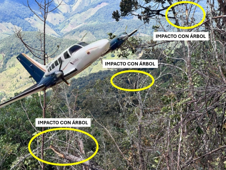
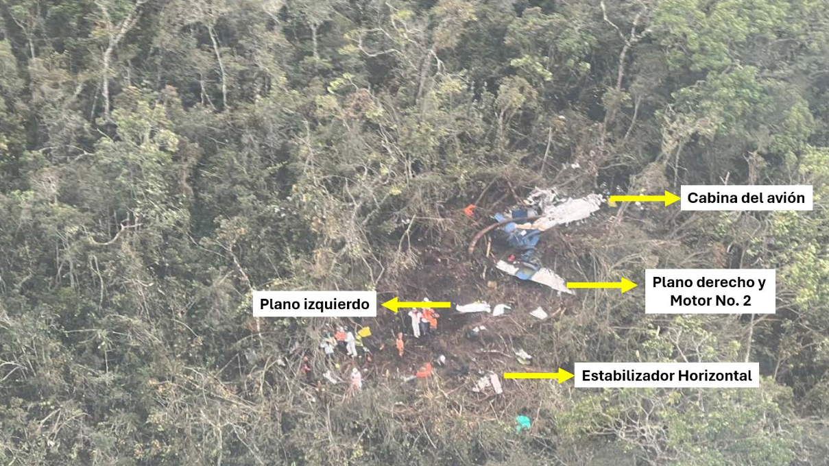
Initial findings suggest the aircraft attempted a sharp climb before impact, as indicated by tree strikes at heights of 20 to 23 meters. The final wreckage orientation was 098°.
Key damage observations include:
- Complete destruction of the fuselage and cockpit
- Separation of both wings, with severe damage to the left wing
- Detachment of the right engine (No. 2) and horizontal stabilizer
- Localized fuel spillage, affecting surrounding vegetation
Weather Conditions and Possible Contributing Factors
While VFR conditions prevailed at the departure and destination airports, certain route sectors were affected by Instrument Meteorological Conditions (IMC).
Infrared GOES-16 satellite imagery recorded convective cloud formations over the area at 17:20, 17:30, and 17:40 HL, with cloud tops between 24,000 and 40,000 feet.
Investigators are examining whether unexpected weather conditions, downdrafts, or local turbulence may have influenced the aircraft’s trajectory before impact.
Emergency Response and Investigation Status
Following the loss of communication, air traffic services activated emergency protocols. The aircraft’s Emergency Locator Transmitter (ELT) sent its first distress signal at 17:41 HL (22:41 UTC).
Search and Rescue (SAR) operations, led by Colombia’s Civil Aviation Authority and the Colombian Air Force, faced logistical challenges due to the rugged terrain.
Response Timeline:
- January 9: Wreckage located
- January 10: First recovery team deployed by helicopter; body extraction began
- January 16: Recovery of the last victim
- January 17: SAR operations concluded
About the Operator: Pacífica de Aviación
Pacífica de Aviación is a regional airline based at Medellín’s Olaya Herrera Airport, operating routes to:
- Capurganá, Bahía Solano, Necoclí, and Nuquí
- Fleet includes Cessna 402C and LET 410 aircraft
Victim Identification
Authorities confirmed the identities of the occupants:
Crew Members:
- Captain Santiago Montoya
- Captain Luis Guillermo Clavijo
Passengers:
- Angie Sanclemente
- Greimar Castro Sanclemente
- Grettel Castro Sanclemente
- Raquel Palacios
- Cristal Sofía Hernández
- Danny Moreno Culma
- Miguelina García
- Yoarledis Valencia
Among the passengers were three minors and multiple members of the same family.
Key Considerations for the Final Investigation Report
Preliminary evidence suggests a Controlled Flight Into Terrain (CFIT) scenario, possibly influenced by weather conditions and loss of situational awareness.
The final report will aim to determine the probable cause of the crash, identify contributing factors, and issue recommendations to enhance safety in non-scheduled flights over complex terrain.
Comentarios
Para comentar, debés estar registrado
Por favor, iniciá sesión